Monitoring the health of new Southern Resident killer whale calves

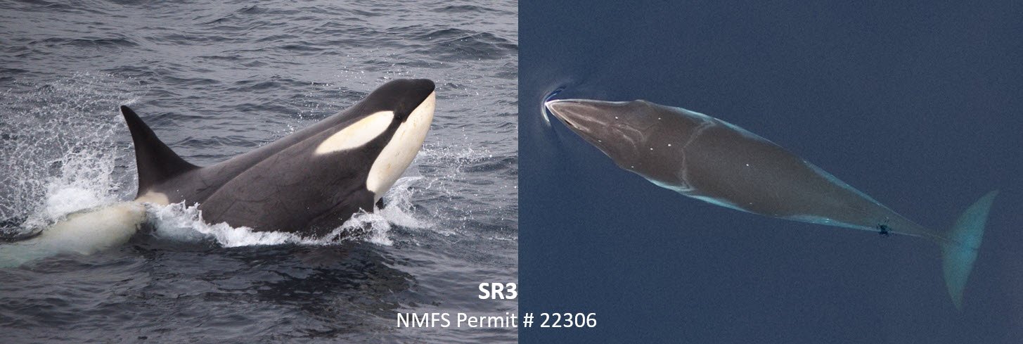
SR3 recently used “photogrammetry” measurements from drone images to report that several Southern Resident killer whale (SRKW) females were measured to be in late-stage pregnancy between fall 2022 and spring 2023, including some that were already expected to have given birth prior to this summer, if brought to full term. The majority of SRKW pregnancies are not successful, but we were very pleased to encounter two new calves (L126 and L127) in L pod in late June and early July. SR3’s research team of Dr. Holly Fearnbach and Dr. John Durban were able to collect aerial images of both calves and their mothers (L119 and L94, respectively), which will be measured to provide important baseline data for monitoring the body condition of the mothers and growth of the nursing calves. The successful rearing of healthy calves is essential for the viability of this endangered population, which numbers just 75 individuals. The team will continue year-round photogrammetry research to monitor the health of these vulnerable whales.

Aerial images of two new calves (left, L126; right, L127 playing with kelp) born into L pod of the Southern Resident killer whale population. Images obtained using an octocopter drone flown non-invasively >100ft above the whales under NMFS research permit 22306 in July 2023.

SR3’s research is protecting the most vulnerable of the vulnerable Southern Resident killer whales

Today the Washington Department of Fish and Wildlife (WDFW) issued an emergency rule requiring commercial whale-watching vessels to stay at least one-half nautical mile away from 11 vulnerable Southern Resident whales this summer, and encouraging all boaters to Be Whale Wise and do the same.

Using measurements from drone photographs, SR3’s Dr. Holly Fearnbach and Dr. John Durban identified one late-stage pregnancy among the Southern Resident killer whale population and 10 members in poor body condition when they were last imaged between September 2022 and June 2023 (as recently as last week). These whales were designated as vulnerable by the emergency rule, which is intended to limit disturbance from vessel noise to maximize the whales’ chances of finding and catching their primary prey, Chinook salmon.

The SR3 research team also documented several additional pregnancies when those individuals were last measured, but based on the timing of when the images were taken, most of the pregnancies have likely ended as of summer 2023. These whales may have calves with them when they return to the Salish Sea, but many pregnancies in Southern Residents result in miscarriages or the death of newborn calves. There are additional whales that also had shape profiles consistent with earlier stages of pregnancy, when viewed from the drone’s unique aerial perspective (see image), but measurements indicated that they had not yet advanced to late stage (defined as the last six months of a 17-18 month pregnancy). We will continue our year-round research to monitor the success of these pregnancies and hope to document improvements in the body condition of the vulnerable whales.

“With this designation, we’re really helping to provide further protection for the most vulnerable of this already vulnerable population,” said Dr. Julie Watson, the WDFW killer whale policy lead. For more information, see WDFW’s news release.

Aerial images showing shape differences of two adult female Southern Resident killer whales during health research in the Salish Sea in spring 2023. Photogrammetry measurements have revealed the whale on the left (J16) to be in poor body condition compared to other adult females and the whale on the right (J22) was in late-stage pregnancy (the pregnancy was unfortunately lost by late June 2023). Images collected by John Durban and Holly Fearnbach (SR3; Sealifer3.org) flying a drone non-invasively at >100ft above the whales, authorized by NMFS research permit #22306.

SR3 Participates in Trainings Featured in NOAA’s West Coast Whale Entanglement Report

Responders train in rescue boats along the California coast during the international whale entanglement responders meeting in 2022.

Every year, dozens of entangled whales are reported by boaters, fishermen, marine agencies, and the public. The recently-released 2022 Entanglement Summary by National Oceanic and Atmospheric Administration (NOAA) Fisheries shows that in 2022, entanglement reporting on the West Coast was higher than what had occurred before 2014, although reports were less frequent than they were during the peak years of 2015-2018.

To ensure SR3 stays on the forefront of technological advances in marine wildlife rescue and rehabilitation, SR3’s Response Program Manager, Dr. James Powell, attended NOAA’s West Coast entanglement training along with responders from the East and West coasts of the US, Mexico, and Canada (see page 3 of the Entanglement Summary for more details). They reviewed recent responses to entangled whales, and analyzed new disentanglement tools and techniques.

A new tool the group was introduced to was a prototype satellite tracking buoy that the Nature Conservancy has developed. Often when an entangled whale is located and a response mounted, there is not enough safe daylight left to operate. In these cases, attaching a satellite tracking buoy to the entangling gear so the whale can be relocated on subsequent days is vital.

This new design for a satellite tracking buoy is more hydrodynamic and lighter weight than the current tracking buoy.

This newly-developed satellite tracking buoy has a profile that is more hydrodynamic than the buoy currently in use. The new design will reduce the drag placed on the entangled whale and is lighter in weight, making it easier for responders to deploy. It also relies on advanced technology that increases tracking accuracy for real-time relocation. In the waters where SR3 responds to entangled whales, it will be particularly helpful because the traditional tracking system relies on satellites that do not align well with the daylight working hours in our area. The new buoy will help to bridge that gap.

SR3 has submitted a request to NOAA to help fund the production of this new prototype tracking buoy for use in the waters off the West Coast. Additional funding will be needed to test the new prototype in parallel with the traditional system, and then to show responders how to deploy the buoys. Since the West Coast entanglement training, Dr. Powell has had many conversations with the leaders of other marine mammal rescue and research organizations on how they can incorporate this new response technique into their existing protocols once production of the buoy systems is complete. 

By collaborating with other groups responding to whale entanglements, SR3 is committed to advancing the most humane and effective means possible to save whales impacted by human activity.

Assessing the year-round health of Southern Resident killer whales

In recent months SR3’s Dr. Holly Fearnbach and Dr. John Durban have continued to collect valuable data on the health of Southern Resident killer whales (SRKWs). The team has been using an octocopter drone to non-invasively collect aerial images of SRKWs throughout the year to document seasonal changes in body condition, adding to data collected in 7/12 months in each of the past two years. In November 2022, the team was able to image the majority of the population in J, K and L pods and so far in 2023, aerial images have been collected of all 25 members of J-pod. SR3’s aerial photogrammetry data has already been used to document a link between SRKW body condition in September and Chinook salmon abundance, specifically J pod’s condition correlating with returning Fraser River Chinook and L pod’s with Chinook returning to Puget Sound. These data from a broader range of months will now allow us to investigate the nutritional health and key prey requirements at other times of the year, with an aim of identifying if and when SRKWs are prey limited and helping to inform adaptive management decisions. Our data on winter and spring body condition are also being used to identify whales in vulnerable condition, to inform adaptive management of commercial whale watch vessels by the Washington Department of Fish and Wildlife. The team will continue collecting data on SRKW whale condition throughout the year, to help guide management actions to maintain adequate year-round prey availability for this endangered population.

Aerial image of a group of J pod Southern Resident killer whales in March 2023. Image obtained using an octocopter drone that was flown non-invasively >100ft above the whales under NMFS research permit 22306.

Fourth year of health research underway on gray whales in Puget Sound

The SR3 team has had a successful start to their fourth year of assessing the body condition of the “Sounders” gray whales during their spring feeding stopover to feed on ghost shrimp in northern Puget Sound. The team uses an octocopter drone to non-invasively collect high resolution aerial images that are measured to assess changes in body condition to infer nutritional health during each spring stopover, and between years. By collaborating with Cascadia Research Collective, measurements from aerial images can be linked to known individuals to track changes in condition of the same whales over time. So far in 2023, aerial images of 10 individual gray whales have been collected over four days. All 10 of these whales have been imaged and measured in previous years, with six of these individuals being imaged in all four years. The reliable use of Puget Sound as a feeding stopover highlights the importance of this area for the whales as they fatten up before they continue to migrate to summer feeding grounds in the Arctic. We will continue to assess the nutritional health of the Sounders until they depart in early summer and results from this study will provide important information on the body condition and health of gray whales during the ongoing Unusual Mortality Event.

Aerial images of the same “Sounder” gray whale (CRC ID #21, “Shackleton”) in each of the past four years. Differences in body condition are quantified by measuring breadths along the profile of the whale, with the leanest profile documented in 2021. Images were collected non-invasively using an octocopter drone flown at >150ft over the whales under NMFS research permits 19091 and 22306.

DECLINING USE OF THE SALISH SEA BY SOUTHERN RESIDENT KILLER WHALES IS LINKED TO DECLINES IN FRASER RIVER CHINOOK SALMON

SR3 contributed to a research paper published this week titled “Traditional summer habitat use by Southern Resident killer whales in the Salish Sea is linked to Fraser River Chinook salmon returns”. Featured in Marine Mammal Science, this collaborative paper used 17 years of sighting data of endangered Southern Resident killer whales (SRKWs) to show that their use of historically preferred summer habitat in the transboundary waters of the Salish Sea has declined by more than 75 % between 2004 and 2020, correlating with a decline in Chinook salmon returns to the Fraser River in Canada. Finding enough food during the summer is essential so that they can fatten up before leaner winter months, and we are already seeing the effects of these changes. We have shown that the body condition of SRKWs, particularly J-pod, is also correlated with the abundance of Fraser River Chinook, with poorer body condition and survival in years with lower Chinook returns. Together, these findings emphasize the need to ensure sufficient Chinook salmon to support a viable population of SRKWs that regularly uses the Salish Sea, and the importance of limiting disturbance so that the whales can forage successfully during their increasingly limited time here. SR3 will continue to monitor the body condition of SRKWs throughout the year, to better understand seasonal changes in prey requirements and inform adaptive conservation measures by state and federal partners.

A young Southern resident killer whale chases a Chinook salmon in the Salish Sea near the San Juan Islands. Image obtained under NMFS research permit #19091. Photograph by Holly Fearnbach (SR3) and John Durban (formerly NOAA Fisheries).

New publication on the social dynamics of Risso’s dolphins

SR3 helped provide data for a paper titled "Detecting Changes in Dynamic Social Networks Using Multiply-Labeled Movement published in the Journal of Agricultural, Biological, and Environmental Statistics. The manuscript, led by Zaineb Boulil and Dr. Henry Scharf of San Diego State University, used our drone-measured movement data on Risso’s dolphins off Santa Catalina Island, California to estimate key social parameters (e.g. alignment, attraction) and infer their disruption from sonar exposure. This study highlights the utility of using non-invasive drone data to quantify dolphin behavior and to help mitigate the impact of ocean noise.

Aerial image of two Risso’s dolphins socializing off Santa Catalina Island, California. Image non-invasively collected using a multi-copter drone under NMFS Research Permit # 19091.

Wrapping up another season on the ice

The SR3 team wrapped up a successful research season in the Antarctic Peninsula onboard the M/V National Geographic Endurance. This research extends a long-term study (since 2009) to assess the health of top consumers (humpback and minke whales) and top predators (killer whales) in the rapidly-warming waters around the Antarctic Peninsula. During the second and final trip, the team collected aerial photogrammetry and photo-identification images of six individual Type B1 “pack ice” killer whales, 20 Type B2 “Gerlache Strait” killer whales and six individual Antarctic minke whales. Aerial images will be measured to monitor growth and body condition of individual whales, while photo-identification images will be used to estimate trends in population abundance over time. Support for this research is from the Lindblad Expeditions-National Geographic Fund.

(Left) Photo of a Type B2 killer whale in the Gerlache Strait and (Right) aerial image of an Antarctic minke whale. Research conducted under NMFS Permit No. 22306 and Antarctic Conservation Act Permit ACA 2017-029.

Top Predators at the Bottom of the World!

SR3’s Dr. Holly Fearnbach and Dr. John Durban, joined by their colleague Kiirsten Flynn, had a great start to their Antarctic research season onboard the M/V National Geographic Endurance. Last week the team was able to collect photo-identification and aerial photogrammetry images of a group of the elusive “pack ice killer whales” (Antarctic Type B1). These are the least abundant type of killer whales found around the Antarctic Peninsula, with recent declines in abundance that are likely due to the loss of sea ice in their habitat. The whales were observed killing a Weddell seal, their preferred prey, and some of these individuals had first been photographed during our research in 2009, providing a 13-year history for these whales. Photo-identification and aerial photogrammetry images will be integrated into SR3’s long-term monitoring data on the health and status of killer whale populations in the rapidly warming marine environment around Antarctic Peninsula. This research is supported by the Lindblad Expeditions-National Geographic Fund. Stay tuned for more updates as this research continues….

(Left) Photo of a “pack ice killer whale” (Antarctic Type B1) with the M/V National Geographic Endurance in the distance. (Right) Aerial image of a pack ice killer whale swimming between sea ice in search of seals. Aerial image was collected non-invasively from > 100ft above the whales using remotely-controlled hexacopter drone. Research conducted under NMFS Permit No. 22306 and Antarctic Conservation Act Permit ACA 2017-029.


Heading back to the ice!

SR3 recently published scientific papers on our research to assess the health of individual whales and their populations around the Antarctic Peninsula. This work is of great relevance for documenting and understanding the impacts of climate change in one of the fastest-warming regions on earth. SR3’s Dr. Holly Fearnbach and Dr. John Durban are now on their way to Antarctica onboard the M/V National Geographic Endurance, for the first time since 2020 due to COVID disruptions. They will continue their research on the health of top predators (killer whales) and top consumers (humpback and minke whales) with support from the Lindblad Expeditions-National Geographic Fund. More updates to come! 

Aerial image of a group of Type B2 killer whales in the coastal waters of the Antarctic Peninsula; note young calves swimming below their mothers. This image was collected non-invasively from > 100ft above the whales using remotely-controlled hexacopter drone. Research conducted under NMFS Permit No. 19091 and Antarctic Conservation Act Permit ACA 2017-029.